UKHO Supports HMS Queen Elizabeth in Portsmouth
Posted by Michelle Howard
August 16, 2017
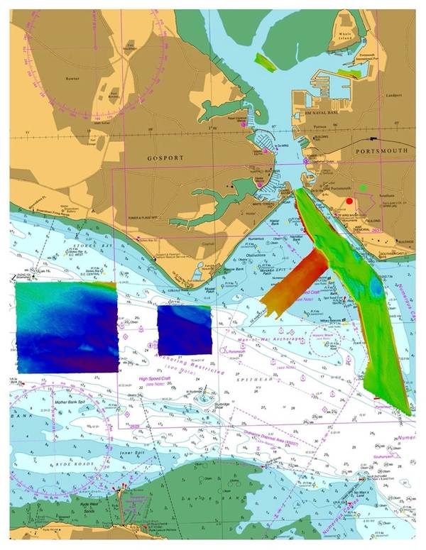
Photo: © British Crown
The United Kingdom Hydrographic Office (UKHO) has supported the safe arrival of HMS Queen Elizabeth into Portsmouth by providing specialist marine geospatial and hydrographic expertise and data capabilities.
Following initial dredging operations to make Portsmouth’s navigation channel and entrance deeper, hydrographic data was collected by the survey launch HMS Gleaner using modern multibeam echosounder technology to confirm the available water depth.
As well as providing advice during data collection, the final dataset was then validated by the UKHO to ensure it was the to the highest Category Zone of Confidence - a criteria used to determine the accuracy and data quality of seafloor coverage for safe navigation purposes. The UKHO then used this information to update Admiralty chart coverage of Portsmouth Harbour and Approaches, to support the safe arrival of HMS Queen Elizabeth.
Working in close collaboration with the Royal Navy, Queen’s Harbour Master and the Defence Infrastructure Organisation, the UKHO also provided its wider marine geospatial expertise to prepare for the arrival, by providing detailed tidal stream predictions and supporting the placement of navigational aids.