The upcoming UN Decade of Ocean Science for Sustainable Development (2021-2030) should herald an increase in marine exploration, aiming to better understand our oceans to reverse the declining health of ecosystems. Heightened knowledge about these waters means a stronger, more effective commitment to even further exploration and to mitigating the impact of weather systems on coastal communities and marine ecosystems.
Weather spotting and its related technologies are not a new industry, nor do they lack in notable achievements. Since the late 1800s, various strategies, including at-sea observations, buoys, satellites, and statistical and modeling predictions have been used to better identify and comprehend weather patterns, both short and long term. However, today we strive for quicker, more accurate and more detailed data for increasingly effective models. To do that, though, we must continue exploring ocean-atmosphere dynamics, which inevitably requires more observational data. Like our struggles with understanding the deep sea, our arsenal lacks data, which is often costly, time intensive and difficult to collect. One group, however, is pushing to change this norm by connecting the world’s oceans together.
Sofar Ocean, a San Francisco-based creator of marine instruments for data collection and weather forecasting, is determined to increase the collection of and access to ocean data, as well as provide critical insights to scientists, communities and industries around the world. Its Spotter technology, designed to autonomously collect data on waves, wind and water temperature, as well as their Smart Mooring, a modular, real-time monitoring platform, play important roles in ameliorating the current shortage of information needed to address the health of our oceans. “We set out to deploy a global distributed sensor network of live weather sensors, driving real-time ocean weather data into models for better forecasts and situational awareness…we can now improve ocean wave forecasts by more than 30%,” said CEO Tim Janssen. This is only the start, he added; by the end of the year, global coverage will be achieved with more than 2,000 live sensors at any given time.
In addition to sensory technology, Sofar Ocean designs modeling platforms, like the Wayfinder, engaging their created ocean networks and gathering “real-time observational data to reduce forecast uncertainty and generate open ocean weather forecasts.” Wayfinder combines data collected from forecasts and live sensors with a “new approach” to ship routing, inspired by dynamic routing solutions on land like Google Maps and Waze. “For vessel routes, the Wayfinder optimization engine finds the best combination of waypoints and speed profiles from hundreds or millions of options, while accounting for economic and operational constraints (ETA, TCI, bunker price, fuel consumption, seakeeping, safety etc.),” Janssen explained.
Weather spotting represents a crucial element to achieve the larger goal of marine exploration and climate awareness. “We cannot manage what we do not understand. And we cannot understand what we do not measure or observe. We know more about the surface of the Moon than we do about our own oceans. And on a planet where our oceans cover more than 70% of its surface area, drive our weather and climate, and fuel over a trillion dollars in annual economic activity, we believe change is needed to enable a deeper understanding of this resource,” Janssen said. Furthermore, such technology can improve understanding and awareness of real-time ocean conditions that impact sensitive ecosystems, like coral reefs. In partnership with Aqualink, an organization focused on ocean conservation technology, Sofar Ocean’s Spotter and Smart Mooring equipment also do just that.
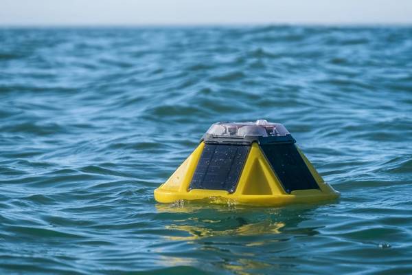
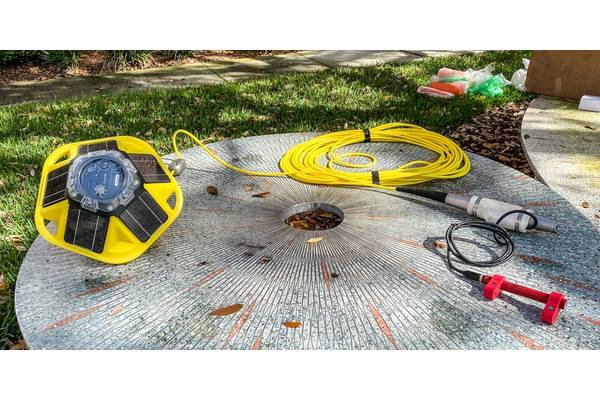
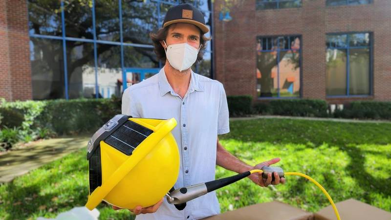 Dr. Mark Buckley of the USGS St. Petersburg Coastal and Marine Science Center holds a new Sofar Smart Mooring and Spotter Buoy that will be used to deliver high-fidelity, real-time wave, water level, and wind data. These data will be used to validate and improve the USGS/NOAA Total Water Level and Coastal Change Forecast, which provides real-time forecasts of water levels and coastal change along nearly 3,000 miles of the U.S. Gulf and Atlantic coasts. © Meaghan Faletti, USGS
Helping the coral reefs
The plight of the world’s coral reefs is well known to even the most amateur of marine fanatics. Damaging activities such as coral mining, pollution, overfishing and coral bleaching (due to warming water temperatures) have decreased reef populations in recent years, bringing alarm and a call to action to the forefront of marine crises. Aqualink, with the support of Sofar Ocean’s technology, aims to create an accessible, up-to-date database of ocean temperature data collected by buoys around the world. The solar-powered and completely autonomous Spotter is able to be deployed in remote locations and the buoys are “mounted along the mooring line, which doubles as a data hub, with one at one meter below the surface and the other just above the ocean floor,” explained co-founder Drew Gray. To date, Aqualink has been able track even large ocean-atmosphere phenomenon like La Niña, a recurring climate pattern that brings cooler water temperatures and lower air pressure than normal (the counterpart to El Niño). Aqualink also encourages community contribution of survey imagery to complement temperature data, whether through an organization or as a citizen scientist. “Visual data offers the ability for scientists to make deeper assessments than they could on temperature data alone, such as the onset of coral bleaching,” added Gray.
Coastal protection
Aqualink is one of many groups utilizing Sofar Ocean’s technology in innovative ways. “We’re excited to empower others,” Janssen said, while pointing out other partnerships, like the University of Tokyo’s use of the Spotter to better understand sea-ice interactions in the Arctic. The U.S. Geological Survey (USGS) has also begun work incorporating the buoys’ abilities, this time working to protect a different kind of oceanic community—one that lives aside it, as opposed to in it.
Scientist Mark Buckley is a member of the USGS Coastal Change Hazards group, focused on improving predictions of wave-driven coastal flooding using field, laboratory and numerical modeling techniques. “As sea-swell waves (4-20 s. period) break on the coast, they transfer energy to lower frequency (infragravity; 20-250 s. period) waves and transfer momentum into the water column generating an increase in the time-averaged water level (wave setup). Sea-swell waves, infragravity waves and wave setup are the three components of wave-driven coastal flooding,” Buckley explained.
During the last two decades, the USGS has invested in research that led to the development of the Total Water Level and Coastal Change Forecast (TWL&CC) model, a collaborative effort with the National Oceanic and Atmospheric Administration (NOAA) that covers about 4,700 km of open, sandy coastline on the U.S. Atlantic and Gulf of Mexico coasts. The TWL&CC Forecast Viewer is a web-based platform driven by simulations of tides, storm surge and offshore wave conditions and is used by the National Weather Service and many local emergency planners. “The TWL&CC Forecast Viewer is validated using camera systems that track coastal flooding, along with wave buoys and pressure sensors that measure wave and water level conditions offshore,” Buckley said. Additionally, Sofar Ocean’s Smart Mooring links a directional wave buoy and its communications system with a pressure sensor mounted on the sea floor. This saves precious time and effort, Buckley explained. “Whereas researchers would normally deploy pressure sensors for several months before retrieving and downloading the data, the data is now available in real-time.”
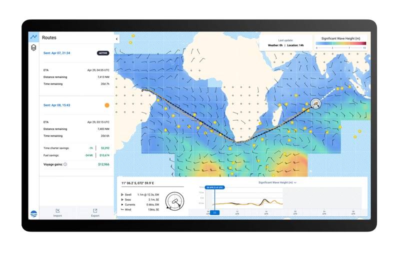 Sofar Ocean Wayfinder vessel routing platform in action. © Sofar Ocean
Looking Long Range
The future of weather spotting and forecasting is one of necessity for impacted communities, ecosystems and industries. A stronger understanding of coastal hazards, as Buckley and the USGS strive for, will allow coastal managers and policy makers to make more informed decisions. The U.S. coastline is home to almost half of the country’s population and extensive protected areas for coastal wildlife. Thus, changes there could have detrimental effects on lives, infrastructure and critical ecosystems, as Buckley pointed out. “Understanding how the coast will change in response to storms, waves and changing water levels can help coastal and resource managers predict and prepare for impacts to their coastal areas, enhancing resiliency in the face of a changing world.”
This future vision is only achievable with more data, though, as Sofar Ocean’s work reminds us. “One of the biggest advances in sensing on land and from space is the concept of distributed networks. For instance, instead of building a single, large and exceedingly expensive satellite with exquisite instrumentation, we build large networks of low-cost satellites with much simpler sensors,” Janssen explained. The value of more data points certainly is hard to dispute. “Our goal is to use our technology to help others to help us grow our ocean data infrastructure,” he added. “Our dream is for a future where interconnected, universally compatible ocean-sensing devices are a reality, ushering in a more sustainable future with universal access to ocean data and insights.”
In a time of rapidly changing climatic patterns and increasing environmental anxiety, the implications of weather-spotting technology represent significant potential for saving and protecting communities, ecosystems and industries that are at the mercy of ocean-atmosphere dynamics. Advancing sensor and modeling technology, paired with innovative users and a ticking clock, will continue to enable meaningful discoveries, fulfilling our decade’s dedication to ocean science and sustainable development.