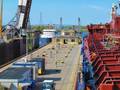
This winter, NOAA will begin a year-long survey of the sea floor in the Port of Houston and Galveston Bay navigational areas, to aid efforts to bring more trade, more cargo, more jobs, and more economic benefits to the Houston area. The navigation survey team arrived in Galveston this week, to begin pre-survey preparations with mariners and federal partners.
"With bigger ships, crowded sea lanes, and more uses of ocean areas, shipping today is increasingly a task of precision and accuracy," explained NOAA Corps Cmdr. Todd Haupt, chief of the Office of Coast Survey's Navigation Response Branch. "Hurricanes can change the shape of the ocean floor and move underwater debris, which can cause problems for mariners. NOAA's navigation team will conduct hydrographic surveys to search for changes caused by Hurricanes Ike and Rita as well as other strong storms."
"Pilots need precise and up-to-date depth measurements as they navigate, and our task is to re-measure the ocean depths, search for dangers to navigation, and give mariners the information they need to protect lives and increase shipping efficiencies." The survey project, part of NOAA's mapping and charting mission, is managed by NOAA's Office of Coast Survey, which produces and maintains the nation's navigational charts. Coast Survey first charted the Galveston Entrance in 1853, after being tasked by the federal government with creating charts of the coastal waters so that the young nation's shipping industry could thrive.
In 2010, over 1.3 billion metric tons of cargo, valued at $1.4 trillion, shipped in and out of U.S. ports in foreign trade. The value of water-borne U.S. exports has more than doubled since 2003, increasing from $206 billion in 2003 to $455 billion in 2010. The Port of Houston plays a key economic role for Texas, and for the United States. A 2007 study showed that 785,000 jobs throughout the U.S. and $118 billion in annual regional economic impact are related to business activities at the Port of Houston.
NOAA has six navigation response teams that survey port areas at the request of port officials or the U.S. Coast Guard. The Texas team is coming from Michigan, where they have been surveying the Great Lakes. The team also worked off the coast of Virginia earlier this year, speeding the resumption of maritime commerce after Hurricane Irene hit the Eastern Seaboard. The navigation response team has a crew of three experienced hydrographers. They use a 28-foot survey boat equipped with both multibeam and sidescan sonar. Most of the acquired data will go to a processing branch in Seattle, Wash., before NOAA applies it to electronic and raster navigational charts updates, but the team will notify the public and appropriate officials if they find any immediate dangers to navigation.
NOAA's navigational charts give pilots the confidence they need to transit the 95,000 miles of U.S. coastline, even in extreme weather and sea conditions. In addition to maintaining the accuracy of paper charts, which are available from chart agents in traditional form or in an updated "print on demand" format, Coast Survey regularly updates electronic navigational charts and raster charts, which are available for free downloads from www.nauticalcharts.gov.