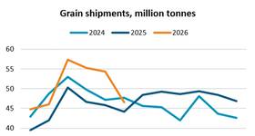
A recent analysis of Australian port state control (PSC) deficiencies revealed several detentions due to incorrect use of charts.
The Australian Maritime Safety Agency (AMSA) has reported a noticeable increase in the use of unofficial charts. Such instances include use of scanned and printed charts by ships to navigate through environmentally critical areas such as the Great Barrier Reef.
AMSA continues to remind masters and operators of ships coming to Australia that carriage of appropriate navigational charts is critical to safe operation and protection of the marine environment.
This issue affects is applicable to all shipowners and operators, not just those trading to Australia. Therefore, all owners and operators should ensure that charts and nautical publications are always correct and up-to-date for the present and the next intended voyage.