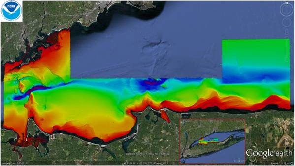
NOAA ship 'Thomas Jefferson' mapping Long Island Sound seafloor this summer contributes to a multi-level data gathering collaboration.
In addition to updating NOAA’s nautical charts, ongoing collaborations in Long Island Sound will create products that depict physical, geological, ecological, geomorphological, and biological conditions and processes – all to balance the development of new ocean uses while protecting and restoring essential habitats.
In 2011, the Long Island Sound Program (representing a partnership between the State of Connecticut, State of New York, Connecticut and New York Sea Grant, and the U.S. Environmental Protection Agency) asked NOAA for help in providing management and technical expertise; acquiring data; and developing products. They required key temporal and spatial information about seafloor conditions in the Sound. They needed bathymetry and backscatter, and biological and physical observational and sampling data, to produce all the products needed by governments, industry, academia, and the public.
It so happened that Coast Survey already had plans for NOAA Ship Thomas Jefferson to survey in Long Island Sound, to acquire new bathymetry for chart updates. With some adjustments to survey areas and project parameters, a mutually beneficial partnership was formed for long-term seafloor mapping of Long Island Sound habitats over the next several years, as an integrated ocean and coastal mapping project.
This summer, Thomas Jefferson conducted hydrographic surveys in the mid-Sound area of Stratford Shoal and vicinity, extending from New York on the north shore of Long Island to the Connecticut shoreline.
“Ocean floors are amazingly dynamic, and we have to chart those changes to provide precise and accurate navigational data for today’s maritime economy,” explained Cmdr. Lawrence Krepp, commanding officer of the Thomas Jefferson and the ship’s chief scientist. “Our data is used to update NOAA’s nautical charts, but the hydrographic information can also be used to support a number of non-navigation uses, ranging from benefits to fisheries management to support of regional ocean planning efforts like this.”