How do you get an aircraft in the far reaches of the Arctic Ocean to the goal, if the compass does not provide reliable location data? Engineers aboard the research icebreaker Polarstern of the Alfred Wegener Institute programmed a Multikopter so that he can navigate near the North Pole, despite declination of the Earth's magnetic field. A first successful test flight together with autonomous landing celebrated scientists recently on an ice floe.
"The autonomous navigation is in high latitudes is a major challenge," says Sascha Lehmenhecker, engineer at the Alfred Wegener Institute for Polar and Marine Research, the Helmholtz Centre for Polar and Marine Research (AWI). "Navigation is by means of magnetic sensors. However, the field lines of the Earth's magnetic field show in pole near almost perpendicular to the ground, so that a precise navigation is difficult. For this reason, commercial Multikopter controls for inserts are unsuitable in polar regions, "said the engineer.
Together with the two graduate students Michael straw Meier and Tobias Mikschl of the University of Würzburg developed Lehmenhecker the control of so-called Multikopter on. This is driven by a number of propellers, about half a meter large aircraft to be sold in the future on ice and after several hours of there own to fly back to a research ship. The special task: Both the ice floe and the ship move. The ship is on the way, to pursue other research tasks and wind, waves and flow drifting ice floes. It is precisely this direction and speed of drift is to capture the Multikopter.
The development team is pursuing two approaches in order to control the multicopter the declination includes in the position determination. "On the one hand, the permanent contact Multikopter via radio to a ground station, which calculated by the GPS data of multicopter the declination. So Multicopter sends its GPS location via radio to a ground station and subsequently send him the corresponding newly calculated coordinates, "explains Sascha Lehmenhecker. "The second approach: We charge by two mounted GPS receivers, the actual change in the position of the aircraft. That's better but also much more complex approach, which we are still at the beginning of the development work, "assigns a AWI engineer.
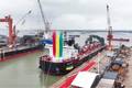
A first test on an ice floe in the Arctic Fram Strait (79 ° north latitude) has recently worked just fine: The Multikopter team had allowed himself to expose together with aircraft on a floe. Away from magnetic interference caused by electric motors aboard Polarstern have manually flew the aircraft about three kilometers to the limits of vision. There they started the autonomous Return program, the Multikopter returned to the pre-programmed coordinates and landed autonomously.
The idea for this development came Sascha Lehmenhecker and his colleagues from the AWI deep-sea group in the use of sensitive devices under the ice. One example is the torpedo-shaped autonomous underwater vehicle (AUV) of AWI deep-sea group called "Paul". He explores the ocean under the sea ice. "For optimum planning his dives, it is important to have access to accurate information about the movement of the sea ice," explains Sascha Lehmenhecker. So far, so-called "Ice Tracker" were applied for by means of an inflatable boat or a helicopter on an ice floe - an expensive and time-consuming process. In addition, the expedition members try if possible to avoid to leave the safe Polarstern. Finally, there is a water temperature of around 0 degrees Celsius, drifting ice floes and polar bears sharp represent additional risks be minimized.
During an expedition in 2012, the deepwater group has used a first developed at AWI Multikopter. This ended up remotely on the ice, stated its position via GPS and transferred them to the research vessel, was supervised by the dive of Paul. As part of the AUV dives of Multikopter thus a navigation task was to support the underwater device. After completion of the dives, the ship had to approach the position of multicopter: A pilot had to fly back to the ship the device by remote control, which only in the viewing area was possible. "The current development increases the operating range of our flying robots of sight up to ten kilometers," Sascha Lehmenhecker pleased about the successful test, the part of the Helmholtz Alliance Robotic Exploration under extreme conditions (ROBEX).