AWT Launches First Service Using Global Automatic Identification System for Accurate Vessel Monitoring. AWT Global AIS Service Expands Coverage to Include Terrestrial Data and Satellite Data.
SUNNYVALE, Calif., September 13, 2011 – Applied Weather Technology, Inc. (AWT) today announced the launch of its global Automatic Identification System (AIS) service, AWT Global AIS. AWT is the first in its market to provide this innovative service, using satellite data to more accurately monitor vessels beyond coastal regions on a global scale.
“With AWT Global AIS, we combine global satellite coverage with terrestrial AIS data to provide fleet managers with maximum coverage, ensuring that they have access to one of the most accurate vessel tracking services on the market today,” said Skip Vaccarello, president and CEO for AWT.
What is the Automatic Identification System (AIS)?
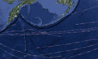
AIS is an automated tracking system used on ships for identifying and locating other vessels and is used in navigation primarily for collision avoidance. The AIS transponders automatically broadcast information, such as their position, speed and heading, at regular intervals via a VHF transmitter built into the transponder. Shipboard AIS transponders have a horizontal range that is highly variable but typically only about 35 nautical miles (NM). However, the signal has a vertical range over 200 NM, and over the past few years polar orbiting satellites have been launched that can pick up these signals. Now, with the launch of these satellites, AIS tracking is possible globally.
The International Maritime Organization’s (IMO) International Convention for the Safety of Life at Sea (SOLAS) requires AIS to be fitted aboard international voyaging ships with gross tonnage (GT) of 300 or more.
Combining AIS with AWT Services
When position tracking is not enough and close monitoring of vessels’ ETAs is needed, customers can combine AWT Global AIS service with AWT’s Tracking Service. AWT inserts the vessel’s track into the AWT Route Optimization System. Using proprietary wind and wave data, vessel-specific speed down algorithms and AWT’s proprietary Climatological Ship Resistance (CSR), AWT can accurately predict when the vessel will arrive at port. The vessel’s ETA is continuously updated throughout the voyage as new weather or position data is received. These vessels are also included in the AWT Daily Fleet Status Report that is sent via email to quickly see if the vessel is falling behind schedule or encountering bad weather.
“With AWT Global AIS data, our customers can now get a more complete picture of each voyage in a timely and cost-effective manner,” says Richard Brown, vice president of product management at AWT. “Combining AIS data with other AWT services lets fleet managers see when a vessel is approaching high-risk areas such as pirate attack regions, as well as detect when a vessel stops before the captain has had a chance to report it.”
AWT Global AIS can also be used with AWT’s GlobalView™ fleet management system to get more accurate information in a visual, easy-to-use format. By combining AIS reports with AWT’s voyage tracking service and GlobalView, fleet managers can closely monitor the safety, ETA and performance of their vessels.
According to Anthony Birch, Marine Assistant, Operations, Africa Express Lines, “AWT’s Global AIS service greatly benefits us. When combined with GlobalView, not only does it give us positioning of the entire fleet on-screen, but you get the added bonus of overlaying the weather, clouds, visibility, waves, current speeds, etc., and this list goes on. It is an invaluable source of information in a neat little package.”
GlobalView is an innovative fleet management system from Applied Weather Technology that combines the latest industry-leading ship routing technology with Google™ Earth to give fleet managers a visual, easy-to-use and powerful system for enhancing safety, saving fuel, time and money and reducing CO2 emissions. Introduced in October 2010 as the first fleet management system to provide critical maritime data within the visual presentation of Google Earth technology, GlobalView has been steadily embraced by clients worldwide, and in June 2011, GlobalView won a prestigious Safety at Sea Award. More information and a video about GlobalView are available here.