Effective June 1, 2013, West Coast shipping lanes are being adjusted to protect endangered whales, & OceanGrafix's new charts incorporate those changes.OceanGrafix, the first and only company to offer NOAA print-on-demand nautical charts,…
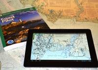
NOAA highlight new US Chart 1, new chart of California waters with IMO TSS shown, and a beta mobile chart app for boaters.New U.S. Chart 1 shows both electronic and paper chart symbologyFor the 65 years since the U.S. Coast and Geodetic Survey issued the first edition of U…
The United Kingdom Hydrographic Office (UKHO) brings to HK its free-attendance workshop on ECDIS regulations and procedures.This free workshop will present the 'Admiralty Guide to policy and procedures for the operational use of ECDIS' and…
U.S. Coast and Geodetic Survey Chart No.1 has described the symbols used on paper nautical charts for 65 years.Mariners have had a standard guide for understanding the symbols, abbreviations and terms used on paper nautical charts since 1948…
The Passenger Vessel Association (PVA) says existing voluntary Code of Conduct sufficient to protect Alaskan Harbor Seals.PVA has submitted written comments to the National Oceanic and Atmospheric Administration (NOAA) urging that the agency…
The need for a comprehensive and risk-aware understanding of Arctic dynamics before proceding with development is emphasised in a recent research paper.The melting of the Arctic is expected to offer prospects for maritime transport and hydrocarbon…
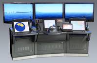
Raytheon to unveil at upcoming CANSEC 2013 Expo an onboard navigation simulator that allows operators to train with the system they will use at sea.Raytheon Anschuetz, a German based, indirect, wholly-owned subsidiary of Raytheon Company, developed the embedded…
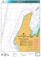
To protect the World Heritage-listed Ningaloo Coast in Western Australia’s north-west region, the Australian Maritime Safety Authority (AMSA) to establish an area ships should avoid.A new AMSA Marine Notice will recommend ships keep at least…
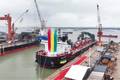
The Canadian Coast Guard (CCG) authorizes the passage of vessels up to 44 metres wide in the Quebec-Montreal section of the St. Lawrence navigation channel. The previous authorized width was 32.1 metres without restrictions. The CCG has…

Uncharted Ice: The U.S. Coast Guard's New Arctic Strategy. U.S. Coast Guard Commandant Bob Papp today revealed the nation's and the Coast Guard's blueprint for Arctic strategy. Long awaited, today's speech at the Willard Intercontinental Hotel in Washington…
At the recent 8th Ministerial Meeting of the Arctic Council, China and another 5 states were granted observer status in the organization.Founded in 1996, the group now has eight member states in the Arctic region, including Russia, the United States…
The Hydrographic Society UK, supported internationally, is arranging a conference: ' Digital Hydrography on the Maritime Web'.The Hydrographic Society UK (THS UK), supported by both the International Federation of Hydrographic Societies (IFHS)…
IMO's Maritime Safety Committee has adopted an earlier recommendation that ships display 3 all-round green lights when crossing the Singapore Strait Traffic Separation Scheme (TSS).The night signals identify these vessels crossing the TSS…
GE’s Power Conversion business debuted its latest Dynamic Positioning (DP) system at OTC. It is more energy efficient, better integrated and—most importantly—more mariner friendly, GE said. Since they were introduced some 50 years ago, DP…
The United Kingdom Hydrographic Office's (UKHO) security charts are designed to protect against risks, including piracy.The two new Admiralty Maritime Security Charts, cover the waters around India and Southeast Asia, including the Malacca Straits…