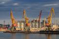
Growing turmoil in Egypt is threatening to disrupt shipments through the Suez Canal and increase the costs for shipping lines as Cairo’s cash-strapped government seeks ways of bringing in revenue, reports Arab News citing a Reuters report…
The Board of Pilot Commissioners for Harris County Ports is requesting public comments on proposed revisions to Section 9 Pilotage Charges of the Rules and Regulations Governing Pilots and Pilotage on the Houston Ship Channel between the Galveston Bar and Turning Basin…
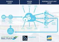
SevenCs together with Australian Reef Pilots and VoyageBank win the ‘ 2013 IHS Safety at Sea Award'.Jointly with VoyageBank and Australian Reef Pilots SevenCs has won the IHS Safety at Sea Awards 2013 in the System category. The successful…
For the second year in a row, the U.S. House Energy & Water Subcommittee, chaired by Rep. Rodney Frelinghuysen (R-NJ), has approved a $1 billion draw from the Harbor Maintenance Trust Fund. The money is for maintaining America’s deep-draft…

Lindley Marinas, specialized in floating equipment, has recently supplied pontoons and aids to navigation to ENAPOR, the Cape Verde port management company. The pontoons were part of the infrastructure created in Porto Novo (Santo Antão…

Northrop Grumman Corporation has been selected by Arklow Shipping to upgrade 12 container vessels with VisionMaster FT Electronic Chart Display & Information Systems (ECDIS).Northrop Grumman's Sperry Marine business unit will install all of the systems by the end of 2014…
The UK P&I Club issue information for members whose vessels call at the remote Alaskan port on the Arctic Circle.Red Dog is a port established specifically to support the associated Lead and Zinc mine. It is a very remote location of Alaska and there are no services…
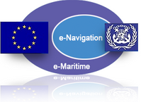
E-Navigation has been a hot topic in the maritime industry for some time, and it is likely that it will continue to be into the future. But for many in the industry, the subject remains an abstraction that everybody is talking about but few can properly explain…

Transas Marine Pacific & local representative win contracts to supply & install Vessel Traffic Management Systems (VTMS) for Samarinda and Banjarmasin ports. In addition to this, Transas will upgrade the current VTS system in the Semarang port with a fully redundant AIS Base Station T214…
Maritime training specialists, STAR Center, upgrades its bridge simulator for an unparalleled 360 degree training experience.Digital Projection International (DPI), an Emmy® Award-winning manufacturer of high-performance projection systems…
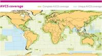
The United Kingdom Hydrographic Office (UKHO) has added two digital charts of the South China Sea to its ADMIRALTY Vector Chart Service (AVCS) to complete the coverage.The cover is now complete for shipping routes from Singapore to China and beyond…
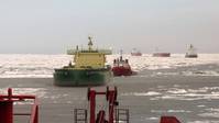
The Northern Sea Route administration has so far given 54 vessels permission to sail the route in 2013. This year’s sailing season on the Northern Sea Route between Europe and Russia will probably be the busiest one ever. The first vessels…
ECDIS compliance using Jeppesen OpenENC 'Pay-As-You-Sail' (PAYS) may be enhanced by using Position Reporting from TracPhone V-IP Series Terminals & Satellite Delivery of Charts over the KVH Mini-VSAT broadband service.KVH Industries plans…
MARIS and Orange Business Servicesa sign agreement to facilitate integrated and digital maritime navigation services.Maritime technology specialist MARIS and Orange Business Services have formalized an agreement to deliver Electronic Chart…
US-based C-Nav Solutions launch its latest GNSS Real-time tide measurement package, C-Tides. The company says that its C-Tides suite combines the exceptional vertical accuracy of C-Nav's GNSS Precise Point Positioning service with the latest advanced ocean and coastal tides models…