EMGS to Map Brazil's Gas Hydrates

November 21, 2014


Electromagnetic Geoservices ASA (EMGS) has received a contract worth USD 1.5 million for a research project in Brazil. The project will use 3D EM data to map shallow gas hydrates in the Pelotas Basin.

The project is a collaboration between the Pontifical Catholic University (PUCRS) of Rio Grande do Sul and Petrobras' Research and Development Center called CENPES.

EMGS will support each stage in the workflow, from survey design and data acquisition to processing and interpretation. The company's services will enable the integration of EM data with seismic and other geophysical and geological information to give explorationists a clearer and more complete understanding of the subsurface. This improves exploration efficiency and reduces risks and the finding costs.

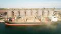
The vessel EM Leader has commenced the survey.

Logistics News

Sara Fuentes Named as President of Transportation Institute

Sara Fuentes Named as President of Transportation Institute

U.S. Coast Guard Counters Maritime Threats With New Special Missions Command

U.S. Coast Guard Counters Maritime Threats With New Special Missions Command

UAE Ports Become Country's Lifeline as Gulf Trade Remains Fragile

UAE Ports Become Country's Lifeline as Gulf Trade Remains Fragile

Great Lakes Iron Ore Trade Increases 5.3% in April

Great Lakes Iron Ore Trade Increases 5.3% in April

Subscribe for Maritime Logistics Professional E‑News

NextDecade sees Middle East conflict boosting long-term LNG ship charters
French aircraft carriers moving into Red Sea, Gulf of Aden
Ship-tracking data shows that a second ADNOC LNG Tanker crossed the Strait of Hormuz during Iran War, showing a second ADNOC tanker crossing the Strait of Hormuz.