The latest seabed survey of the Dogger Bank offshore wind zone takes the cost of the Forewind consortium's spend on offshore surveys to almost £45 million.Since being awarded the rights to develop Dogger Bank in January 2010, Forewind has undertaken a huge range of geotechnical…
US-based C-Nav Solutions launch its latest GNSS Real-time tide measurement package, C-Tides. The company says that its C-Tides suite combines the exceptional vertical accuracy of C-Nav's GNSS Precise Point Positioning service with the latest advanced ocean and coastal tides models…
The 'white gold' is in the form of deep ice cores taken for scientific research from the south polar region for delivery to a Belgian university.The sensitive shipment required global collaboration across several Maersk Line teams. Samples of ice…
The need for a comprehensive and risk-aware understanding of Arctic dynamics before proceding with development is emphasised in a recent research paper.The melting of the Arctic is expected to offer prospects for maritime transport and hydrocarbon…
The recently signed 'Galway Statement on Atlantic Ocean Cooperation' concerns research into the workings of the Atlantic Ocean and its interaction with the Arctic. The alliance will build on existing bilateral cooperation agreements and projects…
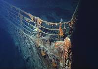
New NOAA report presented to the US Coast Guard examines national oil pollution threat from shipwrecks in US waters.The report finds that 36 sunken vessels scattered across the U.S. seafloor could pose an oil pollution threat to the nation's coastal marine resources…

The 6,000-meter-rated remotely operated vehicle (ROV) system will be tested from 'Okeanos Explorer' in the 2013 field season. Dave Lovalvo, project manager for the NOAA Office of Ocean Exploration and Research’s Deep Submergence Group and…

US Naval Surface Warfare Center with Office of Naval Research (ONR) & academia, is participating in a multi-country, acoustic scattering experiment in the Gulf of Mexico until June 2013. The test event dubbed TREX is a Target Reverberation…
The University-National Oceanographic Laboratory System (UNOLS) seeks nominations & applications to fill Council and Committee vacancies in 2013.The open positions include: • UNOLS Council - 1 position • Deep Submergence…

The US Coast Guard Cutter 'Maple' helps the U.S. Geological Survey to deploy 12 seismic sensors along the Queen Charlotte-Fairweather Fault, northwest of Craig, Alaska.The team placed the ocean-bottom seismometers along a 28-mile section of…

NOAA uses data from a new current meter in New York harbor operated by New Jersey’s Stevens Institute of Technology.The system provides enhanced real-time information to mariners travelling through the nation’s second busiest port.The Stevens current meter measures the direction…

Liquid Robotics, an ocean data service provider and developer of the Wave Glider, was named the 2013 Gold Medal winner for innovation in power generation and utilization.Presented at the 26th Edison Awards Ceremony and Gala event, Liquid…

The FY 2014 President's Budget Request for the National Ocean Service (NOS) amounts to $529.2M.The National Ocean Service (NOS) observes, measures, assesses and manages coastal, ocean and Great Lakes areas and provides science-based services to inform decision making…

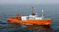
TerraSond Limited announces the return to home base in Alaska of its multi-purpose survey boat 'Luna Sea'.The owners say that this strategic return enhances their capability to serve clients in the Cook Inlet and South Central Alaska.Headquartered in Palmer…
New research tracking the movement of dredged sediment around Liverpool Bay could save millions of pounds in dredging costs.Each year, sediment must be dredged from the port and deposited elsewhere to maintain access for commercial vessels…