
Resolve Maritime Academy has joined the Transas Global ECDIS Training Network, known as Get-Net. The Academy recently expanded its Fort Lauderdale, Florida training facilities, adding a second ECDIS classroom with Transas simulation software…

ChartWorld & SevenCs have moved offices to the heart of Hamburg opposite the BSH (German Hydrographic Office).“As the companies are growing, we now have enough space to accommodate the team now and in the future. The new office and its location…
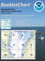
BookletCharts, nautical charts that are easy to download & print from home computers now in official NOAA production.Coast Survey has now moved the BookletCharts from experimental stage into official production. Nearly a thousand newly updated BookletCharts are available free on the Web…
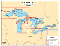
To comply with internationally agreed practices, Canada & the U.S. are eliminating overlapping coverage of electronic navigational charts (ENCs). New changes will soon take effect in the Great Lakes. Under the new ENC coverage scheme, each…

The Panama Canal Expansion is moving forward to reach its goal of bolstering the waterway’s capacity in order to provide a better service. To date, the program is 50% complete. “The program continues to progress and reach milestones while we focus the next phases on building the locks…
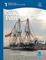
OceanGrafix, now approved as Print-on-Demand (POD) printer/distrubutor for NOAA's US Coast Pilot Series.In conjunction with NOAA’s new process of making weekly online updates to the U.S. Coast Pilot books, OceanGrafix will print the books that reflect all updates and corrections…
Transas Marine has received an order to supply its Navi-Sailor ECDIS systems to the Swedish Armed Forces. After an extensive evaluation, the Swedish Defense Material Administration (FMV) has selected Transas to implement ECDIS on board of eight Swedish Armed Forces vessels…
InterManager, the international trade association for the ship and crew management sector, has started the year by welcoming a new member.Ukrainian crew manager Alpha Navigation has been approved for Full Membership in what InterManager…

Transas Marine Denmark contracted by A/S to supply & install 28 Navi-Sailor 4000 Multifunction Display Dual ECDIS units.Transas is also to upgrade another six Eitzen Chemical vessels to the latest hardware and software ECDIS standards over the next two years…

Following the hubbub created in 2009-2010 by U.S. Customs and Border Protection’s (CBP) proposed modification and revocation of certain Jones Act ruling letters pertaining to offshore operations, all was relatively quiet in 2011-2012 with respect to Jones Act offshore issues…
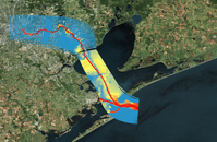
Conrad Blucher Institute Develops Mobile App to Increase Navigational Safety along Nation’s Second-Largest Port. Researchers have designed and are implementing a new mobile application to provide ship captains and pilots with real-time predictions…
Free-to-attend workshops to assist with transition to ECDIS The UK Hydrographic Office has unveiled the first dates of 2013 for its renowned Digital Integration Workshops, the first of which will take place in Limassol, Cyprus on 31 January…
NavTeach.com offers leading edge memory graphics method of effectively learning the USCG Navigation Rules of the Road.Total recall of the complicated and often misunderstood navigation rules of the road for mariners is achieved by remembering…
Jeppesen and Alliance for Safe Navigation partners announce updated 'Boat Smart' white paper emphasizing importance of updated charts for navigation.Jeppesen and its Alliance for Safe Navigation (ASN) partners have released an updated version of the educational white paper 'Boat Smart…
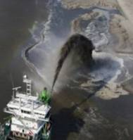
DEME, global dredging & land reclamation specialists, select TERRASTAR-D “Precise Point Positioning” service to work with its Septentrio GNSS receivers.The Belgian dredging and environmental group is exploiting the service using Septentrio…