Wilhelmsen Ships Service (WSS) is helping clients execute voyages through the Northern Sea Route (NSR) as this new trade lane begins to open up new opportunities for shipping.WSS is working with Russian Arctic shipping specialist Rosatomflot…
Russia has offered India joint participation in development of its GLONASS satellite navigation system on an equal basisThe Global Navigation Satellite System (GLONASS), which was officially launched in 1993, is a Russian counterpart to the U…
AtoBviaC offers navigators online calculation of SECA (Sulphur Emission Control Area) & North America ECA (Emission Control Area) distancesThe imminent tightening of fuel control areas around the US is providing ship operators with a new…

BMT ARGOSS has announced that its marine manoeuvring simulator, PC REMBRANDT has been granted DNV accreditation in accordance with Class S- Standard for Certification of Maritime Simulators No. 2.14 January 2011.The purpose of the standard…
On the recent UN World Hydrography Day the Hydrographer of Australia announced enlarged ENC coverage & a new AusENC serviceAMSA's Acting Chief Executive Officer, Mr Mick Kinley, was a guest of honour at a celebration held at the Australian…
Jo Tankers, of Bergen, Norway, choose Transas Marine as an ECDIS supplier for its fleetThe agreement includes upgrade of 3 vessels, retrofit on-board 11 vessels and 6 planned newbuilds.All vessels will be equipped with Dual 26'' Navi-Sailor 4000 ECDIS Premium Multifunction Display…
At a meeting of the International Maritime Organization (IMO) Sub-Committee on Safety of Navigation (2- 6 July in London) the International Chamber of Shipping (ICS) - which represents global shipowners and 80% of the world merchant fleet -…
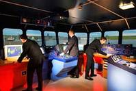
New Kongsberg Maritime simulators for extensive upgrade to South Tyneside College facilitiesKongsberg Maritime has been chosen to supply a suite of upgraded navigation, engine room and Vessel Traffic Service (VTS) simulator hardware and…
MSC Cruises installs a Quality Postioning Services's VP & MS system in its fleetMSC Cruises has worked with independent software design company Quality Positioning Services (QPS) on a high performance, real-time vessel track, trace and emergency monitoring system…
Russia to China bulk cargoes shipped by Nordic Bulk Carriers via theNorthern Sea Route may save them $650,000 on fuel According to Bloomberg, cargoes of dry-bulk commodities hauled through Arctic waters are set to rise to a record this year…
Thomas Gunn Navigation Services (TGNS) has launched Voyager 4, the latest upgrade of its automated chart management systemPacked full of new applications, Voyager 4 offers the mariner an easy to use, cost effective and high quality database…
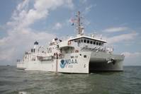
NOAA commissions high-tech coastal mapping 'Ferdinand R. Hassler' in Norfolk, Va. to support NOAA’s nautical charting missionThe new ship’s primary mission will be to detect and monitor changes to the sea floor. Data collected by the ship will be used to update nautical charts…
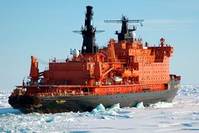
Russia's largest icebreaker will take tourists to the North Pole five times this summerThe world’s largest nuclear-powered icebreaker “50 years of Victory” will take tourists to the top of the world five times this summer, starting from June 26…
Navy Researchers Seek to Improve Weather Prediction for Global Operations.With the Atlantic hurricane season officially beginning this month, the Office of Naval Research (ONR) is pursuing a number of projects to help Navy forecasters and meteorologists around the world predict storms better…
Affiliates of Drew Marine (“Drew Marine”) have reached a definitive agreement with Chemring Group PLC (“Chemring”) to acquire Chemring’s maritime interests (“Chemring Marine” or the “Company”) for a cash consideration of £32 million, subject to standard closing adjustments…