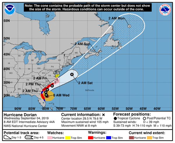
At 800 AM EDT (1200 UTC), the center of Hurricane Dorian was located near latitude 29.5 North, longitude 79.6 West.
Dorian is moving toward the north-northwest near 8 mph (13 km/h), and a northwest or north-northwest motion is expected through this morning. A turn toward the north is forecast by this evening, followed by a turn toward the north-northeast on Thursday morning.
On this track, the core of Hurricane Dorian will move dangerously close to the Florida east coast and the Georgia coast through tonight. The center of Dorian is forecast to move near or over the coast of South Carolina and North Carolina Thursday through Friday morning.
Maximum sustained winds are near 105 mph (165 km/h) with higher gusts. Some weakening is expected during the next couple of days. However, Dorian is expected to remain a powerful hurricane during the next few days.
Hurricane-force winds extend outward up to 60 miles (95 km) from the center, and tropical-storm-force winds extend outward up to 175 miles (280 km). The NOAA automated station at St. Augustine Beach, Florida, recently reported sustained winds of 46 mph (74 km/h) and a wind gust of 59 mph (94 km/h).
The minimum central pressure reported by an Air Force Reserve Unit Hurricane Hunter aircraft is 964 mb (28.47 inches).
HAZARDS AFFECTING LAND
WIND: Tropical storm conditions are currently affecting portions of the northeastern coast of Florida, and should begin along the Georgia coast later this morning. Hurricane conditions are expected somewhere within the Hurricane Warning area in Florida today. Tropical storm conditions will begin within the Hurricane Warning area in the Carolinas later today, with hurricane conditions by tonight.
STORM SURGE: The combination of a dangerous storm surge and the tide will cause normally dry areas near the coast to be flooded by rising waters moving inland from the shoreline. The water could reach the following heights above ground somewhere in the indicated
areas if the peak surge occurs at the time of high tide...
Water levels could begin to rise well in advance of the arrival of strong winds. The surge will be accompanied by large and destructive waves. Surge-related flooding depends on the how close the center of Dorian comes to the coast, and can vary greatly over short distances.