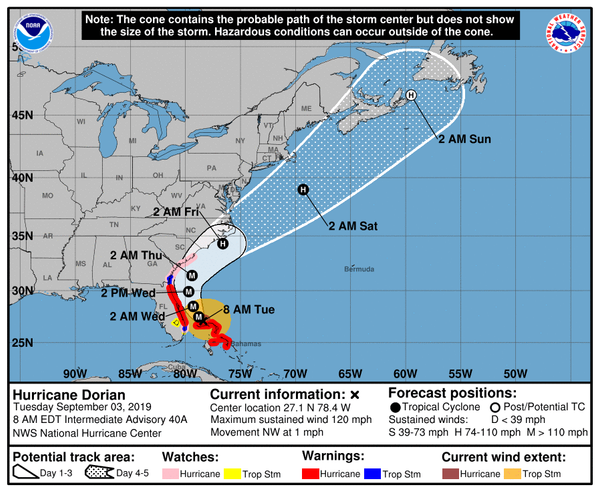
At 800 AM EDT (1200 UTC), the eye of Hurricane Dorian was located by reconnaissance aircraft and NOAA Doppler radar near latitude 27.1 North, longitude 78.4 West. Dorian is beginning to move northwestward at about 1 mph (2 km/h), and a slightly faster motion toward the northwest or north-northwest is expected later today and tonight.
A turn toward the north is forecast by Wednesday evening, followed by a turn to the north-northeast Thursday morning. On this track, the core of extremely dangerous Hurricane Dorian will gradually move north of Grand Bahama Island through this evening.
The hurricane will then move dangerously close to the Florida east coast late today through Wednesday evening, very near the Georgia and South Carolina coasts Wednesday night and Thursday, and near or over the North Carolina coast late Thursday.
Maximum sustained winds are near 120 mph (195 km/h) with higher gusts. Dorian is a category 3 hurricane on the Saffir-Simpson Hurricane Wind Scale. Dorian is expected to remain a powerful hurricane during the next couple of days.
Hurricane-force winds extend outward up to 45 miles (75 km) from the center, and tropical-storm-force winds extend outward up to 160 miles (260 km).
The latest minimum central pressure reported by reconnaissance aircraft is 952 mb (28.11 inches).