The EU sponsored R&D project CORE (Consistently Optimized REsilient Secure Global Supply-Chains) began in 2014. Along the way, it analyzes the use of EGNOS and Galileo for the intermodal transport of dangerous goods, assessing its ability to deliver optimum safety, security and supply chain efficiencies.
Every year, the transportation of dangerous goods amounts to approximately 150 billion tonne-km on European roads, railways and inland waterways. The safety and security of operations are common concerns and as such, localization and tracking technology can help by enabling the continuous reliable control and monitoring of dangerous goods traffic during transport and the collection of data to be further analyzed for statistical reporting and incident prevention.
Traceability and monitoring are therefore key elements both for intelligent and efficient transport logistics, and for ensuring safety and security in the dangerous goods’ supply chain.
State of Play: where Europe is
Tracking and tracing solutions which are widely adopted for the transport of dangerous goods are largely based on the use of devices using satellite navigation technologies (GNSS / Global Navigation Satellite Systems, primarily GPS) for localization and different telecommunication means for data transmission (satellite and/or terrestrial). These devices are installed on board the freight vehicle or on the asset, and can integrate sensors (primarily based on the use of Radio Frequency Identification technologies) to enable the monitoring of the status of the goods.
Stakeholders agree that reliability is a fundamental requirement for monitoring the transport of dangerous goods. This is where the European Global Navigation Satellite Systems (EGNSS), for example, the European Geostationary Navigation Overlay Service (EGNOS), can play a significant role. EGNOS provides three services:
EGNOS Open Service (OS), launched in 2009, is delivered free of charge. It is open for use to anyone with an EGNOS-enabled receiver. This can be any receiver compatible with satellite-based augmentation systems. Being based on GPS, the EGNOS signal does not require major changes for receivers. Today, many mass market receivers available on the market are also EGNOS enabled. EGNOS OS is particularly suitable for mass market and some applications like surveying.
EGNOS Safety-of-life Service (SoL) is authorized for European civil aviation and has been operational since March 2011. EGNOS SoL delivers the integrity message providing the verification of the GPS system and timely warnings (within six seconds), when the system or its data should not be used for navigation. This feature means that EGNOS is able to meet the demands of safety-critical applications in sectors such as aviation.
EGNOS Data Access Service (EDAS) launched in 2012, delivers a terrestrial commercial data service. It consists of a server that gets the data directly from the EGNOS system and disseminates via terrestrial networks in real time, within guaranteed maximum delay, security and performance. EDAS is particularly suitable for professional applications.
EGNOS augments the GPS signal. It provides more precise positioning services (up to 3-4 meters) and in addition, it gives users information on the reliability of the GPS signals, reinforcing data integrity.
Conceived for the aviation needs, EGNOS has interesting perspectives of utilization in other markets. EGNOS OS and EDAS are suitable for the Intelligent Transport Systems (ITS) sector, particularly for those applications requiring accurate and reliable positioning. The receivers available today on the market and integrated within operational systems/tracking devices are EGNOS-enabled. ITS is a combination of Information Technology and telecommunications, allowing the provision of information and services for transport and mobility applications, in all areas of public and private administration.
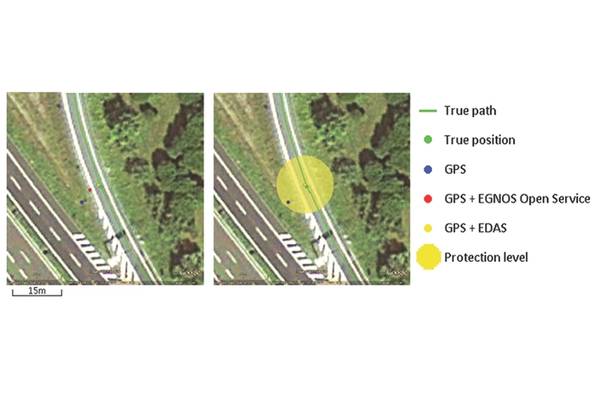
Software solutions and technologies are needed to utilize EDAS, and build/offer commercial value added services exploiting EGNOS features. Figure 1 presents one of the outcomes of extensive trials conducted in various road environments.
Users of the EGNOS OS are able to enhance the accuracy of the position measured with GPS by approximately three meters. EDAS could bring further enhancements by approximately four meters. Moreover, the use of EDAS provides information (called ‘protection level’ and obtained by suitably processing the ‘integrity data’ of EGNOS) for qualifying/guaranteeing the measured position.
Thus, EGNOS can improve the performance of the services delivered by ITS based on GPS only, making them suitable for applications requiring precise and reliable localization.
Where to Go: The Impacts of Robust Localization and Tracking
Safety and security can be greatly enhanced if businesses are encouraged to use robust and reliable real-time tracking & tracing of their shipments of dangerous goods. The newly available ‘precise information’ regarding the status of a certain dangerous material, and of potentially dangerous events that occur which currently go unnoticed, represents fertile ground for many operational and relational improvements in business. At the same time, crucial pieces of data can be provided to regulators that are responsible for public security.
It is a fact that approximately 85% of the shrinkage in the overall supply chain occurs while materials, components or finished goods are in transit. To reduce this figure, reliable technology for tracking & tracing will be beneficial. In order to quantify the potential benefits of a reliable ‘track & trace’ system, one may draw on analysis in “The CIP Report” (a monthly publication issued by the U.S.-based Center for Infrastructure Protection and Homeland Security). Joe McKinney and Arthur Radford affirm that the availability of precise information in relation to supply chain activities results in average cost savings from supply chain operations of 3% to 5% and inventory investment savings of 7% and more. These savings combined will reduce unit cost of goods sold by an average of 0.5%.
Furthermore, economic benefits will derive from the implementation of such technology. First, the various market players will receive a valuable incentive to “go intermodal” by reducing complexity and solving some pressing interoperability issues. Secondly, the rail sector – a backbone of the supply chain system – will benefit from the introduction of EGNOS to track and trace the transport of dangerous goods. In fact, an EGNOS-based solution for rail could provide just-in-time processes and the possibility to establish a responsibility/liability chain in case of delays, with positive impacts on the quality of transport services. Lastly, EGNOS implementation may be a further step towards the simplification of administrative procedures and the adoption of e-Customs.
How do we get there?
As detailed above, tracking systems can improve the efficiency and safety of connecting products with the consumers who buy them each and every day. When dangerous goods are transported, the benefits are not only from the perspective of transportation providers, but also imply public and social interests. Presently, GPS tracking continues to be the most used solution.
In the last decade, various European projects have developed and extensively proven various solutions based on the EGNOS technology, especially for applications and markets for which safety, security and liability play a dominant role. In fact, EGNOS enhanced positioning and integrity provides precise and reliable localization and tracking, and thus meets the challenge of regulations and qualified transport services.
A European Research & Development (R&D) project, SCUTUM, which ended in December 2011, demonstrated that for the transport of dangerous goods, EGNOS adds value to GPS thanks to its accurate and guaranteed positioning that results in higher confidence in the data. SCUTUM proved EGNOS added value compared to GPS alone, and validated the relevant operational benefits in terms of higher safety and efficiency.
Today, because of SCUTUM, EGNOS is used in the operational transport of dangerous goods by road in Europe (Italy, France, Austria, Slovakia, Hungary, Romania, Czech Republic), and around 1,200 road tankers are monitored with GPS+EGNOS. Moreover, SCUTUM also explored other applications for EGNOS in the short term in Europe and in preparation of the global market for Galileo. In particular, the rail transport of dangerous goods was considered by SCUTUM as the next promising step, being rail the sector beside road where EGNOS opportunities have to be exploited further.
Capitalizing on this heritage, the EU R&D project, CORE (Consistently Optimized REsilient Secure Global Supply-Chains), which began in 2014 and will run until 2018, analyzes the use of EGNOS and Galileo for the intermodal transport of dangerous goods, in terms of safety, efficiency and also security. One of the demonstrators developed in CORE extends SCUTUM to the intermodal road-rail transport of chemicals and gas shipped across Europe (“Intermodal transport of Dangerous Goods” demonstrator).
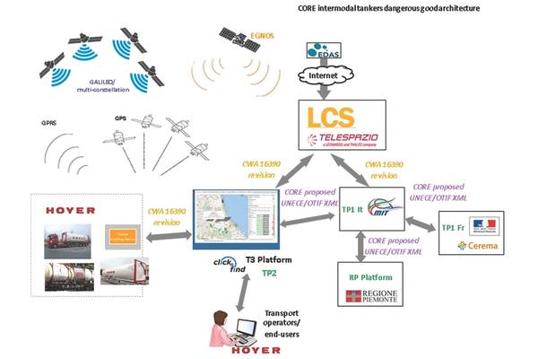
Figure 2 shows the ITS solution developed in CORE for this demonstrator. The solution integrates multi-GNSS technologies, based on the European systems (EGNOS and Galileo), the Russian system GLONASS and the Chinese system BEIDOU, for tracking and tracing the transport of dangerous goods.
The solution is validated in life operations and in real business cases of intermodal tankers transporting Argon throughout road-rail paths across Europe, from Germany to Italy, and from Austria and France to Italy. HOYER, a European transport company operating in the sector of chemical and gas, and Italy’s and France’s Ministry of Transport are involved in the demonstrator, providing the perspectives of the business and the authorities’ stakeholders.
CORE’s solution for the “Intermodal transport of Dangerous Goods” demonstrator contributes to the implementation of the Cooperative-ITS (C-ITS) in Europe, and specifically to the creation of value added services oriented to the transport of special goods and sensitive materials.
The Author
Antonella Di Fazio works at Telespazio, an Italian company that is part of the Leonardo/Finmeccanica-Thales space alliance, and having satellite services core businesses. Antonella is in charge of satellite navigation applications & services. She is the coordinator of the CORE demonstrator related to the transport of dangerous goods.